Traffic violation capture systems are an essential part of intelligent transport systems. These systems, which combine several tools like drones, cameras, and radar, use cutting-edge technologies to accomplish the efficient monitoring of traffic violations as well as their handling and the issuing of fines.
Drones have a share role in capturing traffic violations and managing traffic. Together with their high point of view and adaptability, as well as image and video recognition technology, they can very well document various kinds of violations like illegal parking on the road, unauthorized use of the emergency lane, lorries entering areas that are off-limits, changing lanes at the intersection, running through red lights, lane encroachment, driving against the traffic, and not using the designated lane. Furthermore, drones can fabricate three-dimensional models of accident scenes, thus, they become an absolute necessity to the police. Most importantly, their thermal imaging ability enables them to pinpoint vital signs at the accident site and hence, save lives by facilitating the work of the rescuers.
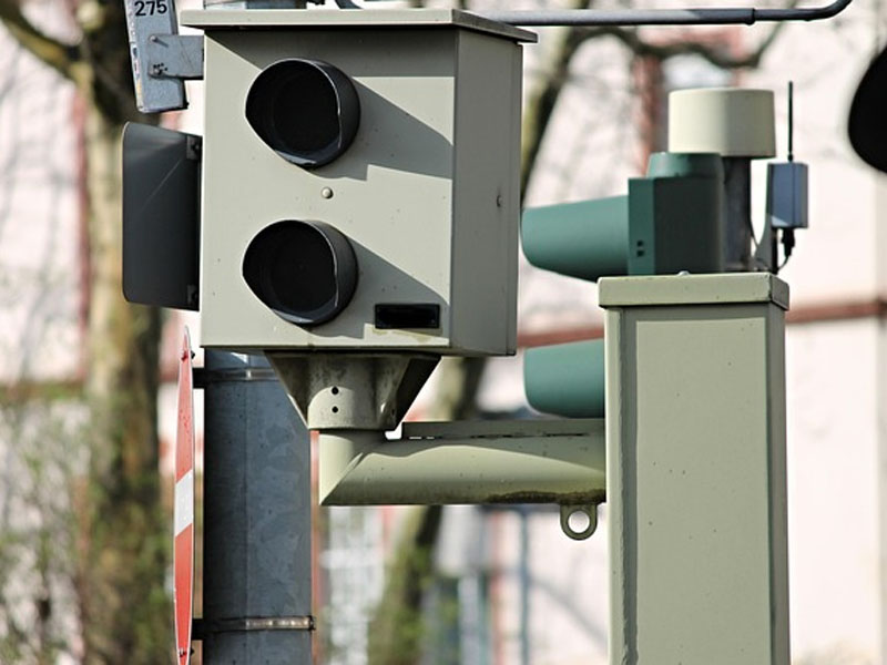
Cameras are at the heart of the traffic violation detection system. Their vehicle documentation capabilities are very strong, with illegal parking documentation covering areas within 250 meters. These systems can achieve very high accuracy in license plate recognition while they are also capable of measuring traffic flow parameters like vehicle volume, queue length, average lane speed, lane time occupancy, and lane space occupancy with ranges that are no less than 200 meters. To guarantee the best identification performance and coverage, several intelligent perception cameras can be installed at each main intersection or the most heavily trafficked road sections, thus, they are capable of complete and blind-spot-free monitoring.
Radar can collect traffic data very well. It is capable of gathering various data about traffic such as the exact location and speed of the vehicles, number of vehicles and types, average speed, headway, inter-vehicle distance, and vehicle type at any time of the day or night. It also comes with anomaly detection features, that is, it can speedily identify happenings such as speeding, driving against the flow of traffic, unauthorized entry, abnormal parking, illegal lane changes and road congestion at road sections and intersections, and at the same time, produce the respective event information. Besides that, radar has exceptional target ID detection and tracking features which help it to maintain the same vehicle IDs throughout the entire section of the monitored area. It allows continuous vehicle tracking, by different radar systems and as well camera systems.
The integration of "AI + Big Data" technology enables the system to identify a large number of illegal behaviors, smartly recognize abnormal vehicles, and create the recovery evidence through the intercepted images and route reconstruction. The evidence is sent to the operator's audit team for confirmation, which significantly enhances the audit process. Simultaneously, by using big data along with visual algorithms for vehicle detection, and data analysis for daily revenue reporting, operators are able to get a real-time view of the revenue situation that helps them manage operations more efficiently.
On the data integration and coordination front, cameras, and radars synchronize their time through edge computing nodes. Radars spot vehicles and send the information including vehicle ID, latitude/longitude, distance, speed, size, and detection time to these nodes. On the other hand, cameras get the target information like the number of the license plate, the pixel coordinates within the video frames, and the color of the target which they also send to the nodes. The edge computing node aligns the data chronologically and fuses it based on parameters such as target distance, speed, and size thereby achieving target fusion between radar data and video imagery. The data that has been fused is sent to the data center servers through wireless, fiber optic or 5G communication for storage, further fusion, display, and application processing.
When it comes to the coordination between the systems, for instance, if the system directs the cameras to take pictures of the breaking of the rules, millimeter-wave radar will be the one to start the event functions when it detects vehicle offences and will output the target coordinates. Cameras-view coordinates will be the ones where these coordinates will be changed to, hence cameras will be automatically updated with the focus based on the target distance and the control pan-tilt rotation will be on the basis of the angular data will according to cameras. This allows for target tracking, photography, and identification to be the most accurate possible. Violation capture is thus assured at its best thanks to the precision in targeting, taking pictures, and recognition.
FAQ – Frequently Asked Questions
1. When and where will the Expo be held?
The Expo is scheduled to be held from May 13 to 15, 2026, at Hall C, Xiamen International Conference and Exhibition Center (XICEC), Xiamen, China.
2. What is the exhibition scale?
The event covers 40,000 m² of area with 350+ companies exhibiting and it is expected to attract 30,000+ professional visitors from all over the world.
3. What activities are included?
Over 80 professional forums and events will provide in-depth discussions on topics such as smart mobility, transport communication, safety, and sustainable development.
4. How many countries and regions are involved?
There will be participants from over 80 countries and regions, thus making it a global summit for intelligent transportation innovation.
5. Are there opportunities for cooperation?
Yes. With more than 1,000 global partners, The Expo is rich in possibilities for collaboration, sharing of advanced technologies, and attracting investment.
6. Who can I contact for details?
For more details, please contact the Organizing Committee via the Contact Us section on the Official Website.